Situated about 200 metres above the lay-by on the B4391 road to Bala from Ffestiniog. Access can also be gained from
Dubach y Bont, which lies 200 metres to the Northeast. The lake is fairly easily accessible on foot and easily fished and holds a good head of brown trout, rainbow trout also stocked occasionally each season.
Approx 30 Acres.
Map Reference - GR SH736425.
Height 1,300’
15 Minutes walk from the layby on the Migneint.
Season Starts - 3rd March
Season Ends - 30th September
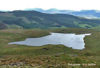
Morynion is the Ffestiniog District's main water supply, situated approximately 1200ft above sea level, but easily reached via a 15 minute walk from the car park adjacent to the B4391, above the spectacular "Rheadr Cynfal", (Cynfal Waterfalls). The lake has a good head of natural, free rising, Brown Trout, and is stocked twice annually to supplement the native stock.
The fish are quick risers and weigh between 1/2 and 3/4 lb on average.
Some triploid Rainbow Trout were introduced in 2004, fish of between 1 and 4 lb.
Early season, i.e, April and May, dark flies tend to produce most fish, Black Pennel, Black & Peacock Spider, Viva and Bibio being particular favourites.
June, July and August are evening and night fishing months, when any sedge imitation will "winkle out" the better trout.
Lately, the "Muddler" style of fly, in dark, sombre colours have worked very well.
The local "Rhwyfwr" flies are also used to to imitate the sedge family, many of these patterns are a hundred years old, but are still used successfully.
Good advice, and these local flies can be found in the towns tackle shops.
There is safe wading in most areas, but as of 2005 Float Tubing is allowed, (at your own risk of course).
Spinning and bait fishing is also allowed, a "walk and cast" session should see you around the lake in about an hour.
Spectacular scenery and peacefull surroundings, with only the odd Curlew to disturb the peace make Morynion well worth a visit.
Tight Lines (Genwair Blyg)
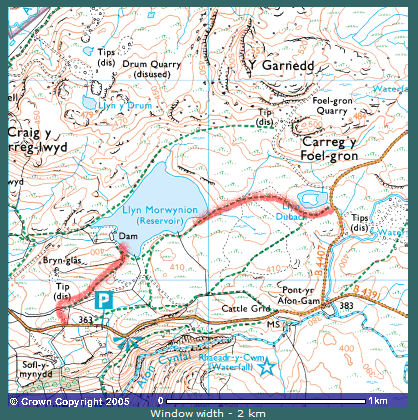
Image produced from the Ordnance Survey Get-a-map service. Image reproduced with kind permission of Ordnance Survey and Ordnance Survey of Northern Ireland